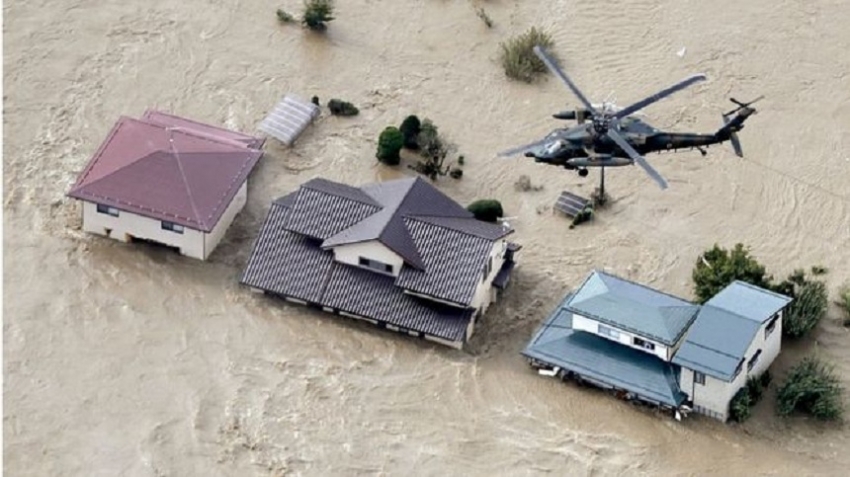
Helicopters rescued people trapped in their homes when the Chikuma river burst its banks
At least nine people are reported dead as Japan recovers from its biggest storm in decades.Typhoon Hagibis triggered floods and landslides as it battered the country with wind speeds of 225km/h (140mph).Rivers have breached their banks in at least 14 different places, inundating residential neighbourhoods.The storm led to some Rugby World Cup matches being cancelled but a key fixture between Japan and Scotland will go ahead on Sunday.Hagibis is heading north and is expected to move back into the North Pacific later on Sunday.
It made landfall on Saturday shortly before 19:00 local time (10:00 GMT), in Izu Peninsula, south-west of Tokyo and moved up the east coast. Almost half a million homes were left without power.In the town of Hakone near Mount Fuji more than 1m (3ft) of rain fell on Friday and Saturday, the highest total ever recorded in Japan over 48 hours.Further north in Nagano prefecture, levees along the Chikuma river gave way sending water rushing through residential areas, inundating houses. Flood defences around Tokyo have held and river levels are now falling, reports the BBC's Rupert Wingfield-Hayes in Japan.Officials said some of those killed were swept away by landslides while others were trapped in their cars as floodwaters rose. Another 15 people are listed as missing and dozens are reported injured.
More than seven million people were urged to leave their homes as the huge storm approached, but it is thought only 50,000 stayed in shelters.Many residents stocked up on provisions before the typhoon's arrival, leaving supermarkets with empty shelves.
A huge clean-up operation was under way in Kawasaki near Tokyo"Unprecedented heavy rain has been seen in cities, towns and villages for which the emergency warning was issued," Japan's Meteorological Agency (JMA) forecaster Yasushi Kajiwara told a press briefing.Many bullet train services were halted, and several lines on the Tokyo metro were suspended for most of Saturday.All flights to and from Tokyo's Haneda airport and Narita airport in Chiba have been cancelled - more than 1,000 in total.
Two Rugby World Cup games scheduled for Saturday were cancelled on safety grounds and declared as draws - England-France and New Zealand-Italy. The cancellations were the first in the tournament's 32-year history.Sunday's Namibia-Canada match due to take place in Kamaishi was also cancelled and declared a draw.The US-Tonga fixture in Osaka and Wales-Uruguay in Kumamoto will go ahead as scheduled on Sunday, organisers said.
Meanwhile, a crunch game between Scotland and tournament hosts Japan on Sunday will now go ahead. The decision followed a safety inspection.Scotland against Japan to go ahead The Japanese Formula One Grand Prix is also taking place on Sunday.
Local resident James Babb spoke to the BBC from an evacuation centre in Hachioji, western Tokyo. He said the river near his house was on the brink of overflowing."I am with my sister-in-law, who is disabled," he said. "Our house may flood. They have given us a blanket and a biscuit."
Tornado-like winds whipped up by the typhoon struck east of Tokyo Andrew Higgins, an English teacher who lives in Tochigi, north of Tokyo, told the BBC he had "lived through a few typhoons" during seven years in Japan."I feel like this time Japan, generally, has taken this typhoon a lot more seriously," he said. "People were out preparing last night. A lot of people were stocking up."Only last month Typhoon Faxai wreaked havoc on parts of Japan, damaging 30,000 homes, most of which have not yet been repaired."I evacuated because my roof was ripped off by the other typhoon and rain came in. I'm so worried about my house," a 93-year-old man told NHK, from a shelter in Tateyama, Chiba.
Hurricanes, typhoons and cyclones: What's the difference?
Hurricane Florence is likely to cause prolonged torrential rainfall Hurricane Florence has arrived on the eastern seaboard of the United States.At the same time, Super Typhoon Mangkhut is approaching the Philippines.There are spectacular images of both shot from space, and the two weather systems look almost the same.So why do we call one a hurricane and the other a typhoon? And while we're at it - what exactly is a cyclone?All tropical storms They are all the same thing: tropical storms. But they are known by different names in different locations. In the North Atlantic Ocean and Northeast Pacific, they are called hurricanes. But if the same type of disturbance takes place in the Northwest Pacific Ocean, it is known as a typhoon.And in the South Pacific and Indian Ocean, cyclone is the correct term.
How bad do storms have to be?A tropical cyclone is a generic term used by meteorologists.It means a rotating, organised system of clouds and thunderstorms that originates over tropical or subtropical waters, according to the National Oceanic and Atmospheric Administration of the US."Once a tropical cyclone reaches maximum sustained winds of 74mph (119km/h) or higher, it is then classified as a hurricane, typhoon, or tropical cyclone, depending upon where the storm originates in the world."Your guide to Hurricane Florence's risksHurricanes are categorised between 1 to 5 based on their wind speed.
When do they occur?In the Atlantic, it is hurricane season between 1 June and 30 November. More than 95% of tropical cyclone activity occurs during this period in this egion.Typhoons in the Northwest Pacific Ocean are most common from May to October, although they can form year-round.And in the South Pacific, it's cyclone season between November and April.
How are they named?The World Meteorological Organization, a UN body, maintains a list to name tropical cyclones around the world.The names of the deadliest ones like Typhoon Haiyan or Hurricane Katrina are retired and replaced.Countries in the regions of hurricanes, typhoons and cyclones send suggestions for the list to the global met authority.Philippines Typhoon Mangkhut: 'People are tying down their roofs'
"Eight countries in our region, which covers the Bay of Bengal and the Arabian Sea, sent the list to the WMO during the early 2000s," a senior scientist with the Indian Meteorological Department told the BBC."Nearly 50% of those names for cyclones have been exhausted."The agreement between the countries in our region then was to make sure that the names do not hurt religious sentiment in our countries."
The science: How storms form Air rises quickly when it is heated by warm sea water.As the air cools down again it is pushed aside by more warm air rising below it.This cycle causes strong winds. Over the sea, a tropical storm can whip up huge waves.When these waves reach land they can flood large areas, including towns and cities.Over land the strong winds can cause a lot of damage - they can flatten homes, knock over trees and even tip over cars.
Mangkhut is forecast to strike northern part of Philippines on 14 September.
Scientists say the temperature of ocean water is going up and that can lead to hurricanes increasing in intensity in the future.They add that a hotter atmosphere can also hold more water, so this should allow hurricanes to dump more water on affected areas.There are many factors which make the relationship between climate change and hurricanes a complex one.